The Dr. Simon Baruch Public Bath, opened on the Lower East Side in 1901 as the first public bathhouse in NYC, was shuttered during the city’s 1975 fiscal crisis
Help Find Our Unused NYC Parks Department Buildings
We are finding places for New Yorkers to create the community resources we need, and we could use your help. Skip to the instructions.
Our work so far has revealed that dozens of buildings in NYC parks were built in the 1930s and 40s as community centers, public baths and restrooms, closed during NYC’s fiscal crisis in the 1970s, and have not yet reopened.
Documenting the unused buildings in our public parks will help us reveal historical patterns and create opportunities to change course, as residents living near neglected public spaces envision how they can serve the public again through our stewardship. Unsurprisingly, abandoned Parks Department buildings, like vacant lots, are concentrated in low income neighborhoods of color whose blocks are marred by histories of disinvestment, urban renewal clearance and municipal neglect. Unused NYC Parks Department buildings could be space for meetings community centers, public bathrooms, small and cooperative businesses, community based organizations, and so, so much more.
Local campaigns to reopen Parks Department buildings have sparked and are gaining traction in neighborhoods where we have focused this work so far. Together, we can reveal our shared assets and make the city we want to live in.
See our emerging picture of NYC Parks Department buildings across the whole city at Living Lots NYC.
Help us reveal the opportunities for new neighborhood spaces that are hiding in the city’s shared backyards! Below are instructions for volunteers who want to investigate abandoned public buildings in NYC parks in three steps. Email organizers@596acres.org to introduce yourself. And dig in!
Organize a groundtruthing bike ride in your neighborhood to identify unused Parks Buildings! Interested? Email mara@596acres.org.
Step One: Improve Available Public Data
At 596 Acres, we often start with available public data about our shared public assets, and then improve it so that it becomes useful to people who live nearby. Plug in to this: pick the spreadsheet for your borough: Manhattan, Brooklyn, Bronx, Queens, Staten Island.* Find a location relevant to you. Look at the column titled VOLUNTEER’S NAME and put in your name. Under STATUS, select “WORKING ON IT.”
Look under the OASIS LINK column and GOOGLE STREET VIEW LINK column. Is there a link for your building? If not, your first step is to add these links. Here is how to find them:
A. Oasis Link
- Open OASIS map and enter the block and lot under the “Block & Lot” tab.
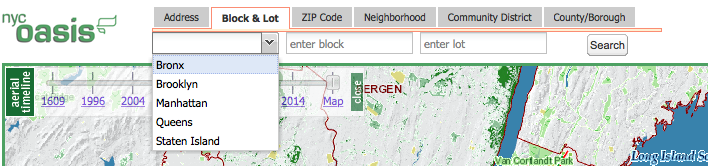
- Once the lot has been found, use the tools on the right side to click off the layers on the land in order to take a look at the buildings that might be there (grey silhouette of a building will show up if that is the case).
Before removing any layers:
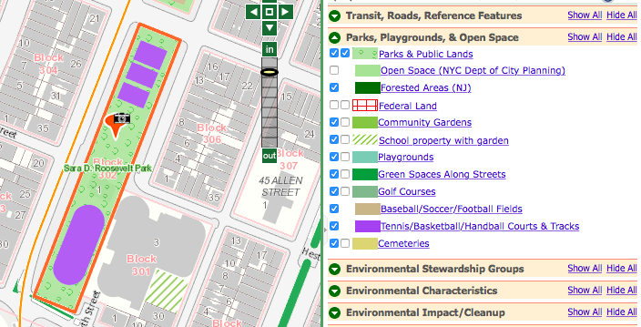
After unclicking the “Parks & Public Lands” and “Tennis/Basketball/Handball Courts & Tracks” layers:
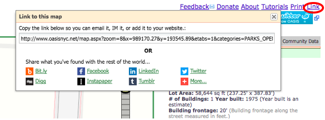
- Retrieve/save the link by clicking on “Link” on the top right corner. Copy and paste it to the OASIS LINK column of the spreadsheet.
B. Google Street View Link
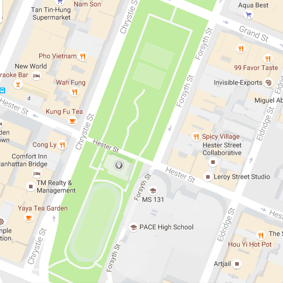
- Take the address from OASIS and find the park and building on Google Maps:
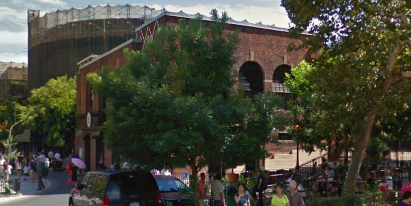
- Through the surrounding streets, try and get a look at the building through Google Street View:
- Copy the URL from the address bar and paste it to the GOOGLE STREET VIEW LINK column of the spreadsheet for your building.
- If your building is open and fully accessible, select “MAINTAINED AND OPEN TO THE PUBLIC” from the drop-down menu in the column labeled BUILDING USE, and select “DONE” from the drop-down menu in the column labeled STATUS. There is no need to do more work.
If you are not sure whether the building is open or accessible, use your judgement and decide whether to visit the site and ground truth. If you believe the building is closed or underutilized, do move on to STEP 2: GROUND TRUTH.
*We made these spreadsheets by accessing a list of NYC Parks Department properties through NYC’s OpenData portal (we searched “Number of Structures > 0”) and then narrowing down the the City’s 27,000+ rows of data to remove duplicate entries. Our spreadsheet for Manhattan is the most improved: we went through available online data (on OASIS and Google Maps/Google Street View) and have been able to preliminarily map out around 40-50 unused buildings in the Manhattan borough.
Step Two: Ground Truth
Visit the building in your neighborhood park to determine what’s really going on. Take pictures! Add what you find to the spreadsheet in the following ways:
- Under the COMMENTS/DESCRIPTION column, detail whether the building is closed, open or used for storage. Likewise, we’ve included a drop-down menu under the BUILDING USE column so that you can select “MAINTAINED AND OPEN TO THE PUBLIC” or “NEEDS ADVOCACY,” depending on what you find.
- For some of the parks you will notice that they might be under redevelopment/redesign; take a look at the Parks Department’s Capital Project Tracker to see if they’re working on the structures/buildings you are reviewing; you can include this on the COMMENTS/DESCRIPTION column too!
- If you also come about any press links that you want to include, you can do so under the PRESS column on the spreadsheets.
- If you’re not sure about a bathroom building, you can check the park’s webpage for an indication that the bathroom is open (e.g., https://www.nycgovparks.org/parks/nelson-playground). Sometimes there may be capital work happening, but that work might not actually encompass reopening the building or bathrooms (e.g., https://www.nycgovparks.org/parks/seward-park—capital work is just on improving the roof).
If your building is open and fully accessible, select “MAINTAINED AND OPEN TO THE PUBLIC” from the drop-down menu in the column labeled BUILDING USE, and select “DONE” from the drop-down menu in the column labeled STATUS. There is no need to do more work, so do NOT add open and accessible sites to the Living Lots map.
If your building is closed or underutilized, select “NEEDS ADVOCACY” from the drop-down menu in the column labeled BUILDING USE and move on to STEP THREE below, where you can add your photos and create a platform for organizers to begin organizing to reopen these spaces.
Step Three: If Your Building Needs Advocacy, Map It at Living Lots NYC
Follow these steps to add the building to Living Lots NYC, where you can add your photos and create a platform for neighbors to connect and advocate together for our buildings:
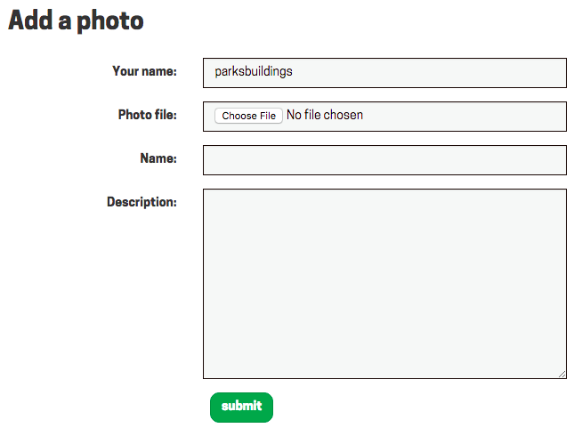
- Log in to the site on http://livinglotsnyc.org/admin/
Username: parksbuildings
Password: nycnyc - Type http://livinglotsnyc.org into your browser address bar to go back to the main map.
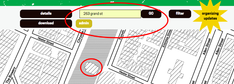
- Enter the address to the lot you want to map out into the search bar:
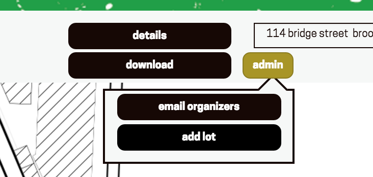
- Click the yellow “admin” button, then “add lot”; a new menu will pop up, then click on “draw lot”:
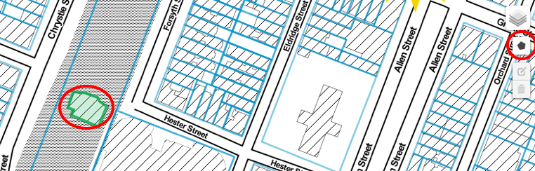
- After that, you’ll notice a polygon shape on the right side of the screen, circled in red below. Click on it and begin to trace the building on the lot where you are working:
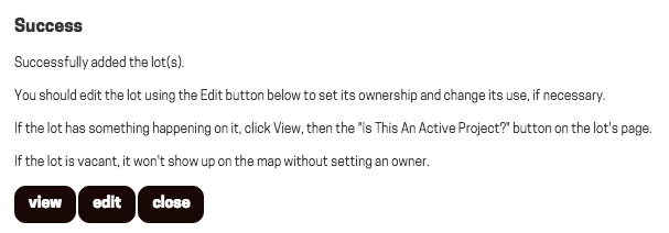
- Once the drawing is done, click on “add lot” again. A window will pop up. Click “OK” to create the lot with the parcels you’ve drawn. This will prompt the following success message:
- Hooray! Click “edit.” On the edit page, fill in the basic information as follows:
a. Name: [Park Name] – [Building Name] (e.g. “Sara D Roosevelt Park – Hester Street Building”)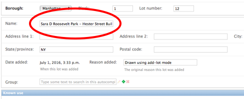
b. Owner: choose “New York City Department of Parks & Recreation – building (public)” from the list of options that will appear when you begin to type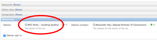
c. Delete anything that appears in the field called “Bbl” at the top. For your new lot to appear, this field must be blank.
d. Leave “Known use” blank (——–) as well.
e. Finally, click “Save” at the bottom right. The lot will now be saved on the Living Lots map! - Click “View on site” on the top right to go to your new lot page! Go back to the spreadsheet. Copy and paste the URL from Living Lots NYC to to the LIVING LOTS LINK column for your building. (Here is what the example we used above looks like: http://livinglotsnyc.org/lot/6000010012/. You can also access the lot page through the Living Lots NYC map, clicking “filter,” and filtering for “public land > New York City Department of Parks & Recreation – building.”)
- Back on the Living Lots lot page, check the street view image that appears at the top. If it looks strange, you can fix it: Click “Edit this lot” (the yellow button) to go back to the backend. There find “Geography” and click on it. You will see two map panels. The one called “Centroid” controls the street view perspective. You can move it around to get a better look at the property by clicking the “Edit layers” button (the one that looks like an arrow going into a square). The Centroid will have a pink rectangle around it. Use your cursor to move the rectangle. Once you have it in a place you like, click “Save” next to the “Edit layers” button. Click “Save” at the bottom right of the page.
- Go back to your new lot page. Once there, add your notes, photos or files along with any information that will be helpful to advocates. Now, anyone can upload pictures, notes or files–no need to log in! You may want to link in press pieces, or even write in what you envision as a bright future for this public building. Simply click “note,” “file” or “photo” and upload! It looks nearly the same for files and notes:
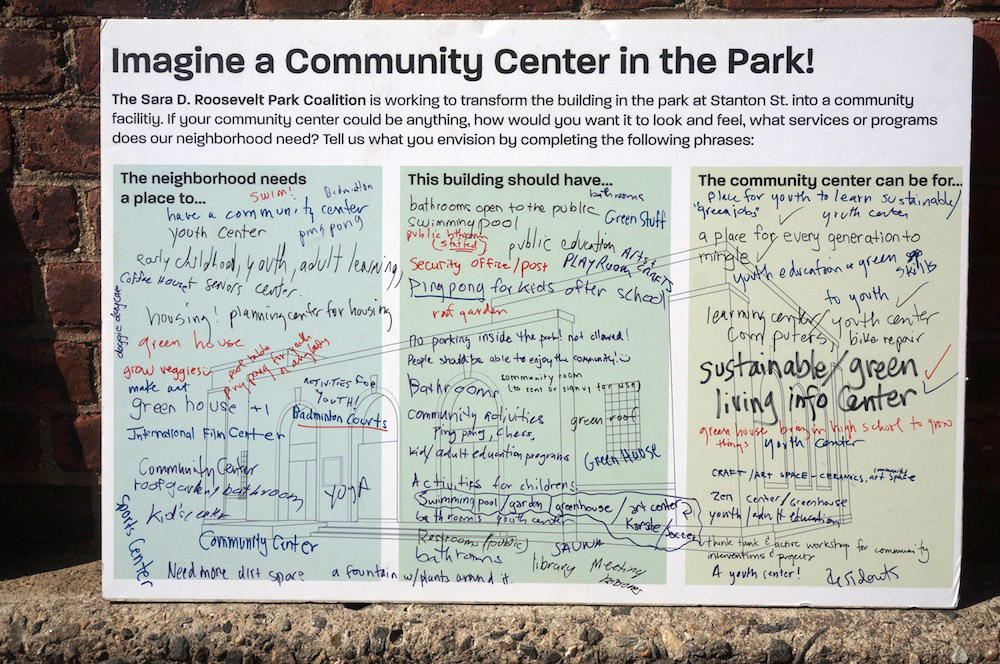
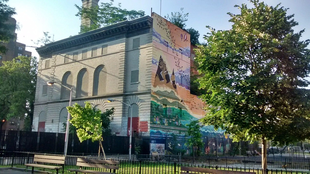
Community ideas for a proposed community center in a long-closed building in Sara D. Roosevelt Park (photo by Francisco Miranda)
Closed Buildings We’ve Already Found
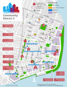
View full map (PDF)
We have identified and mapped over 30 closed Parks Department buildings across NYC. In summer 2016, we made this map of ten closed Parks Department buildings in the Lower East Side’s Community District 3. In summer 2017, groundtruthers visited and mapped more unused Parks buildings across Manhattan, Brooklyn, the Bronx and Queens. Already, our work has supported community members envisioning future uses and advocating to reopen these parts of our shared infrastructure. Click the names below to learn more about each building and campaign for access on Living Lots NYC. If you live nearby and want to plan for the future of these structures with your neighbors, sign up to Organize:
Manhattan
- Bath House at Baruch Houses, Community District (CD) 3
- Stanton Building at Sara D. Roosevelt Park, CD 3
- East River Park Building, CD 3
- Tompkins Square Park Building, CD 3
- Allen Street Mall, CD 3
- Hester Street Building at Sara D. Roosevelt Park, CD 3
- Baruch Playground Building, CD 3
- Seward Park Building, CD 3
- Playground Building at LaGuardia Houses, CD 3
- Corlears Hook Park Building, CD 3
- Broome Street Building at Sara D. Roosevelt Park, CD 3
- McKinley Playground Restroom, CD 3
- Dewitt Clinton Park Building, CD 4
- 102nd Street Fieldhouse in Riverside Park, CD 7
- Peter Jay Sharp Volunteer House in Riverside Park, CD 7
- Arched Structure just east of Skate Park 109 in Riverside Park, CD 7
- Access building for West Side railway tunnel in Riverside Park, CD 9
- Arcade in an arched structure in Riverside Park, CD 9
- Comfort Station in Fort Washington Park, CD 12
- Bathroom building currently used to store equipment from tennis courts in Fort Washington Park, CD 12
- Locked area under pedestrian bridge in Fort Washington Park, CD 12
- Door in wall of Highbridge Park, CD 12
- Former Fire Dispatch Building in Central Park, Joint Interest Area 64 (Central Park)
Bronx
- Franz Sigel Park Comfort Station, CD 4
- Tremont Park – Comfort Station on E Tremont Ave and 3rd Ave, CD 6
- Poe Park Bandshell, CD 7
Queens
- Queensbridge Park Field House, CD 1
- Ravenswood Playground Building, CD 1
- Building in Springfield Park, CD 13
Brooklyn
- Building in Bushwick Inlet Park (on former Bayside Fuel Oil Depot site), CD 1
- WNYC Transmitter Park Building, CD 1
- Fort Greene Park Building, CD 2
- Cadman Plaza Restroom, CD 2
- Ashford Playground Comfort Station (PS 287), CD 2
- Red Hook Park Concession Stand, CD 6
- Bensonhurst Park – Tennis Facility, CD 11
- Betsy Head Pool – Observation Deck, CD 16
- Litchfield Villa – Rear house in Prospect Park, Joint Interest Area 55 (Prospect Park)
- Grand Army Plaza Memorial Arch, Joint Interest Area 55 (Prospect Park)
